Trailhead Car Prowls in Western Washington: The Data, the Hotspots, and What Actually Works in 2026
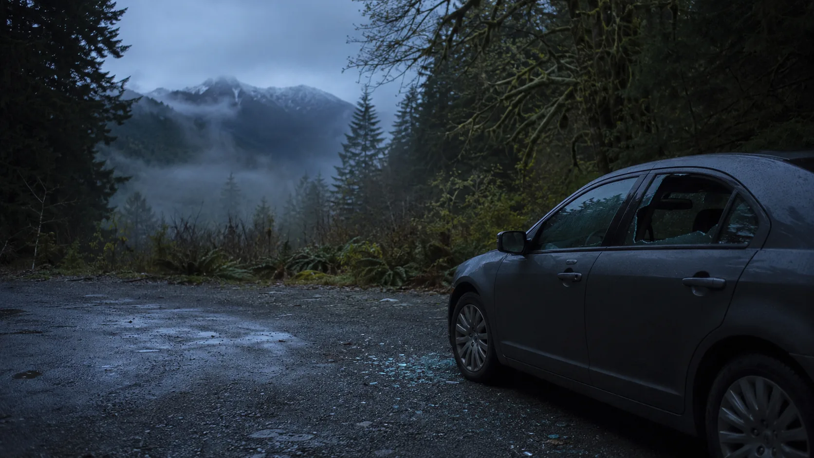
Between 2020 and 2021, the number of cars broken into at Western Washington trailheads doubled — from 389 to 780 in a single year. A King County Council proposal to put cameras and signage at the worst lots quietly stalled. Volunteer watches in Bellingham have helped, but they don't scale. And the cars keep getting hit, every weekend, at the same six or seven trailheads. Here's what the data actually shows, where the hotspots are right now in 2026, and the one thing that finally moves the needle for the jurisdictions managing these parking lots.
Quick Facts
Why Trailhead Car Prowls Became the Region's Most Orphaned Crime
Trailhead parking lots have a fundamental security problem that doesn't exist almost anywhere else in our region: nobody owns the security responsibility. A King County Parks trailhead might be patrolled by the King County Sheriff. A neighboring DNR trailhead in the same drainage is technically a Department of Natural Resources jurisdiction. Drive ten minutes up the road and you're inside the Mt. Baker-Snoqualmie National Forest, which falls to the U.S. Forest Service. Cross a ridge and the next lot might be Washington State Parks, with Washington State Parks Rangers, plus whatever county sheriff happens to be on duty. The result, as one journalist who's covered the issue extensively put it, is that no one thinks they have responsibility for dealing with petty property crime.
That patchwork is the single biggest reason the data is so bad. Trail-crime statistics don't even live in one place — the same hiker who compiled the most-targeted-trailhead list in 2022 had to send public records requests to over three dozen separate agencies just to get a partial picture. The U.S. Forest Service in particular has been criticized for not publishing easily accessible crime reports for its parking areas, even at the most famously targeted lots. Hikers who get hit at a trailhead don't really know who to call: many never report at all, because there's a sense (mostly correct) that nothing will happen.
Layer on top of that the demand side. The pandemic permanently widened the audience for Puget Sound hiking; trailhead parking at the most popular sites (Mount Si, Rattlesnake Ledge, Poo Poo Point, Granite Mountain) overflows by 8 a.m. on a Saturday. King County's own Trailhead Direct bus service — specifically created in part to reduce car volume and theft exposure at popular lots — saw Mount Si ridership jump 125% in a single year between 2021 and 2022, and the service was renewed for the 2025 summer season. More cars at more remote lots equals more targets, full stop. Every car contains the same predictable mix of valuables: wallets, backpacks, electronics, often-recent purchases tossed in the trunk before a Saturday drive up I-90.
And finally, organized rings are good at this. The crews who hit Eastside trailheads aren't opportunistic teenagers. In 2018, Bellevue-area detectives broke up a ring of about 13 arrested suspects linked to roughly 150 incidents across Bellevue, Kirkland, Redmond, Issaquah, Sammamish, Seattle and Kitsap, with total documented losses around $200,000. The rings rotate trailheads to stay ahead of any one jurisdiction. They scout the same way you'd case a parking lot at a mall — cars left unattended for hours, predictable departure windows, no one inside the vehicle to interrupt them, and no cameras anywhere. As recently as February 2026, Eastside agencies were still arresting suspects tied to active Bellevue–Redmond–Kirkland car-prowl operations, with stolen IDs and credit cards recovered from the vehicle.
The Hotspots: Where the Cars Actually Get Hit
Across more than a decade of incident data, the same handful of trailheads keep showing up. The pattern is geographic: the closer a trailhead is to I-90, I-5, or another major exit ramp, the more often it gets hit. Crews need a fast escape route. The further you drive into the actual back-country, the lower the risk — not because remote trailheads are inherently safer, but because they're not worth the gas to crews working a route.
The Issaquah Alps
Cougar Mountain Regional Wildland Park — specifically the Whittaker Wilderness Peak trailhead — sits at the top of nearly every list of most-targeted lots in Western Washington. AllTrails reviewers and the Washington Trails Association both warn explicitly about leaving valuables in vehicles here. Just up the ridge, Margaret's Way made local news in 2022 when an April incident saw all seven vehicles in the lot vandalized in one morning. Tiger Mountain's Poo Poo Point trailhead is in the same orbit; one well-publicized 2022 incident saw a stolen credit card lifted from a Poo Poo Point car and used the same afternoon to ring up about $7,000 in charges at Apple and Nordstrom in Bellevue Square.
The I-90 Corridor: Mount Si, Rattlesnake Ledge, Olallie
The North Bend cluster — Mount Si, Mount Teneriffe, Rattlesnake Ledge, and the various Olallie State Park trailheads — absorb a huge fraction of the Puget Sound's weekend hiking demand and a corresponding share of its trailhead break-ins. Olallie in particular became a national news item when a 2022 car-prowl attempt escalated into a carjacking: four suspects in a Dodge Charger fired shots at a witness, crashed their own car, and hijacked a Subaru Forester from a victim they pulled out of her driver's seat. The Living Snoqualmie account of the Olallie incident captured what local rangers had been quietly telling reporters for years — a sleepy state park trailhead five minutes off I-90 isn't the low-risk place it looks like.
Mountain Loop Highway, Snohomish County
The Mountain Loop Highway, snaking from Granite Falls past Big Four Ice Caves and the Sauk River back to Darrington, is one of the most consistently hit corridors in the state. The HeraldNet has tracked the pattern for years — one weekend in 2020 saw about 25 vehicles broken into across Goat Lake, Barlow Pass and Mount Pugh trailheads. Snohomish County deputies have stepped up patrols periodically, but the corridor is too long, too remote, and too unsupervised between patrols to fix with rover patrols alone.
The Chuckanut Corridor and Whatcom County
Further north, the trailheads along Chuckanut Drive south of Bellingham have their own well-documented problem. In a single April-to-April window, Whatcom County logged 92 reported incidents at trailheads — about 24% of the county's total reported car prowls for that period. North Chuckanut Mountain trailhead has been singled out by name in multiple incident reports.
Mount Rainier National Park
On the federal side, Mount Rainier has its own jurisdictional layer (National Park Service, federal Western District of Washington) and its own pattern. A repeat offender prosecuted in federal court in Western Washington was tied to prowls at four-dozen-plus vehicles across at least seven different trailheads and lots, including Rainier sites. The Washington Trails Association's official car-prowl advice opens with a first-person account of a WTA editor whose car was hit at the Frying Pan Creek trailhead inside Mount Rainier. For Pierce County operators, the Carbon River and Mowich Lake access lots on Rainier's western side are the closest analog — lightly patrolled, no power infrastructure, hours from the nearest sheriff response.
Pierce County and Tacoma
Tacoma's own recreation lots see a quieter version of the same problem. Point Defiance Park's 760-acre footprint — the largest urban park in Washington, with Five Mile Drive, the Owen Beach lot, and the dozens of pull-offs along Spine Trail and Outer Loop — is patrolled by Tacoma Police, but the park's geography (cliffs, dense second-growth forest, long blind sight lines) makes any kind of foot patrol coverage thin. Federation Forest State Park east of Enumclaw, the various Foothills Trail trailheads through Buckley and Orting, and the Pierce County–operated regional park parking areas all share the same recreation-lot risk profile: easy access, valuables in cars, no cameras, no power, no fast law-enforcement response. We covered the broader public-space safety picture in our deep dive on Tacoma's public space safety problem.
Why This Is a Genuinely Different Security Problem
A trailhead parking lot is not a normal parking lot. The things that make every other kind of lot at least a little defensible — ambient foot traffic, adjacent businesses with their own cameras, streetlights, a neighbor who might notice somebody loitering — are absent. So is most of the security infrastructure people take for granted closer to town.
There's no power. Most trailheads are not on the grid. The handful that are usually have a single 120V drop for a vault toilet light or a payment kiosk, and that's it. Permanent IP cameras typically need conduit, a sustained power source, and either an Ethernet run or an unobstructed cellular signal. Trenching a conduit run from a forest-service kiosk to even a 100-foot-distant camera mount through wet, rooty PNW soil is a five-figure project, and most of the agencies who manage these lots simply do not have the capital budget to do it.
There's often no cellular signal. Some of the worst hotspots are deep enough in the foothills that LTE is unreliable. The carriers' coverage maps lie in this part of the state — a "5G" pixel on a Verizon map can be a hard-walled dead spot in practice once you're behind a ridge. Any camera system has to be able to either buffer to local storage and upload when signal returns, or fall back to a different carrier.
There's no fast response. Even when an incident is happening in real time and somebody dials 911, the nearest sheriff or ranger unit may be 25 to 40 minutes out. Crews know this. They time their entries to the window between scheduled patrols. The High Country News piece linked above made a point that I think understates the issue: in the trailhead environment, the criminals are operating with information asymmetry. They know the patrol schedule. The hikers don't know they're targets until they hike back to a broken window.
There's no central data. If your distribution-center yard gets hit three weekends in a row, you'll know, because it's the same operator and the same insurance carrier and the same police precinct each time. If three Mountain Loop trailheads get hit on the same Saturday, that's three separate sheriff's reports, possibly three jurisdictions, and almost certainly no aggregation. The Washington Hikers and Climbers Trailhead Security Forum — a community group on Facebook — ends up being the most-current "database" of what's getting hit and where, which tells you everything you need to know about the official picture.
What's Been Tried — and What Hasn't Moved the Needle
In July 2022, King County Councilmember Reagan Dunn introduced a four-part proposal to address the worst trailhead lots. The Dunn proposal called for: warning signage at known high-incident lots; better data collection across agencies so the actual scope of the problem could finally be measured; video surveillance cameras at the highest-incident trailheads; and a volunteer trailhead lookout program. It was a reasonable plan. It is also, four years later, mostly not implemented in any visible way. The expansion of Trailhead Direct happened. The cameras did not. Most of the signage did not. The cross-agency data system did not.
Other approaches have been tried piecemeal. Bellingham organized a volunteer watch program with about 250 participants across roughly a dozen popular lots, and it appears to have helped at the lots it actually covers, but it's not a model that scales to the dozens of high-risk trailheads across four counties of Puget Sound. Periodic sheriff's-office patrol surges — Snohomish County, King County, and others have all done them after media attention — produce a temporary drop in incidents while the patrols are running and a fast rebound when they stop.
The hiking community has, predictably, started adapting. WTA's standing advice is now to leave anything valuable at home, hide what you can in the trunk, and carry essentials in your pack. Some hikers go further and deliberately leave their cars unlocked, on the logic that a broken window costs more than whatever's likely to walk out of an empty cabin. That's a real coping behavior, and it tells you how little faith the community has in the official approach.
The plain truth is that signage and PSAs reduce hiker losses (when hikers actually leave valuables at home) but do almost nothing to deter the actual crews. The crews want the signage there — it confirms they're in the right place. Volunteers reduce incidents at specific lots while volunteers are present. Patrols work while they're running. None of these scale to the actual geography of the problem.
What Actually Moves the Needle: Mobile Surveillance at the Lot
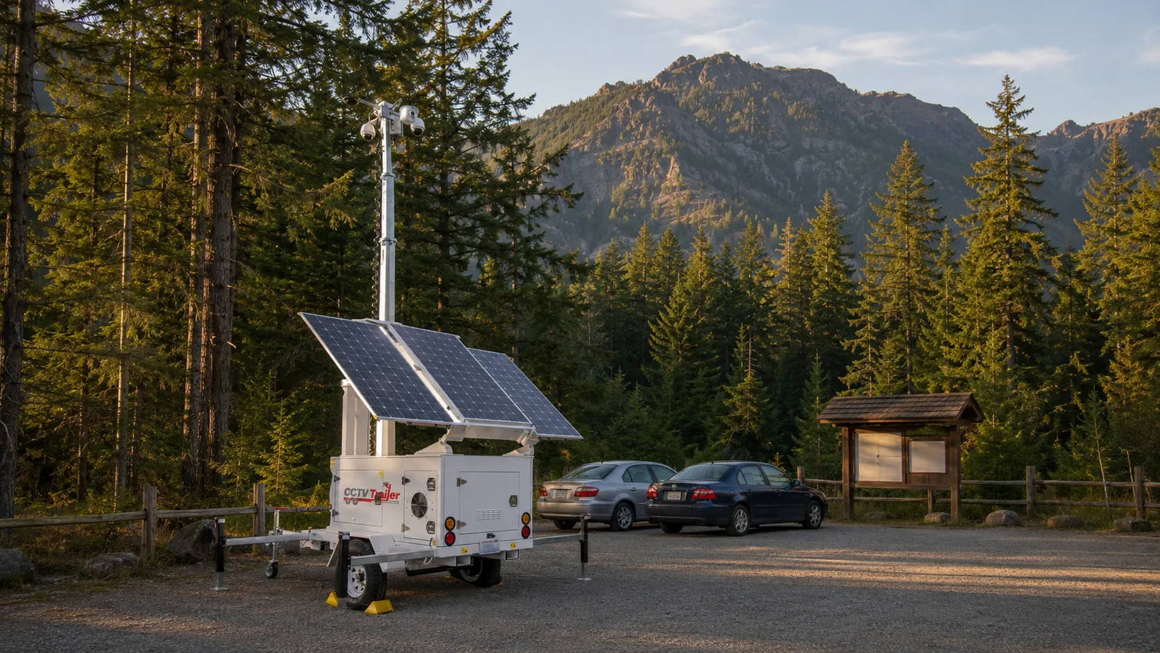
The thing that finally makes a difference at trailhead lots is the same thing that's worked for us at remote construction yards, port-adjacent industrial sites, and rural distribution-center pads: a visible, recording, cellular-connected camera platform that doesn't need the lot to have any infrastructure of its own. In our world, that's a solar-powered mobile surveillance trailer with a 25-foot mast, AI-driven motion detection, two-way speaker, and a cellular uplink with carrier failover.
The reason this works at trailheads, specifically, is the combination of factors:
- It self-powers. No electrical service at the lot is needed. A roof of solar panels and an onboard battery bank runs the cameras 24/7 through Pacific Northwest winters — we sized for the actual sun-hours problem.
- It uplinks over cellular, with failover. Multi-carrier modems mean that even at marginal-signal lots, footage is either uplinked live or buffered locally and pushed when signal returns. There's no fiber to cut and no conduit to trench.
- It's visible. A 25-foot mast with cameras and a strobe is unmistakable from across the lot and from the trailhead. The crews scouting the area pick a different lot. This is the actual deterrent — not the recording itself.
- It generates the evidence package. The recording quality — in our case using S-VIDIA's FDC compression technology — is court-admissible. License plates are readable. Times are stamped. The volunteer-watch model produces a person who says "I saw something." A trailer produces a file that a prosecutor can introduce.
- It moves. The same trailer that was at Mount Si this weekend can be at the Mountain Loop pull-off next weekend. For a county or state-park system managing a dozen problem lots on a rotation, that flexibility is the actual product.
This is exactly what the 2022 Dunn proposal called for and didn't get built — the camera leg of his four-part plan. The other three legs (signage, data, volunteers) are still worth doing. But the missing piece is the one that finally gives crews a reason to drive past a particular trailhead instead of into it.
A Note for Public-Lands Managers
We work with general contractors, port operators, and event organizers across the Puget Sound, but we also work with county parks departments, transit agencies, and (under the right contracting vehicle) federal land managers. If you manage a trailhead, park, or recreation lot that's been a repeat hotspot, the deployment model is straightforward: month-to-month, weekly, or rotating coverage on a multi-site cycle. See the pricing page for standard rates, or get in touch for a coverage assessment.
A Practical Framework for Trailhead and Recreation Lots
For the agencies and operators thinking about this seriously — whether you're King County Parks, a DNR recreation district, a state park, a tribally-managed recreation area, or a private landholder with a leased trail-access parking arrangement — here's the framework we've seen work.
1. Identify your top three lots by incident concentration
The Dunn-proposal data leg is the right starting point even if you're doing it agency by agency. Pull whatever incident data you have, cross-reference with any sheriff's or police reports for the lot's address, and rank lots by reported incidents per parking-space-hour rather than raw count. (A 200-stall lot will out-incident a 12-stall lot in raw terms even if the smaller lot has a much worse hit rate.) The top three are where surveillance pays back fastest.
2. Cover them in a rotation, not all at once
You don't need a permanent camera at every lot. You need to break the predictability that crews depend on. A single trailer rotated across your top three lots on an unpredictable schedule produces most of the deterrent effect of three trailers permanently installed at one-third the equipment cost. We did this exact rotation pattern for a public-lands client across Pierce and King counties through summer 2025.
3. Add visible signage — but only at lots with actual surveillance
Signage saying "this lot is under 24/7 video surveillance" is highly effective when it's true and easily verifiable from the lot. It is counterproductive when it's a bluff and the crews who scout these lots can see in 90 seconds that there's nothing actually deployed. Sign only what you can back up.
4. Run real incident reporting from the trailer's logs
The recording itself produces the data that the Dunn proposal said we didn't have. Motion-triggered events, license-plate captures, time-stamped clips. Even at a single high-priority lot, a season of trailer footage typically gives the local sheriff something concrete to work with for the first time — which is exactly the missing-data leg of the original proposal.
5. Coordinate with the hiking community
The community groups — WTA, the regional climbing federations, the trail-running and mountain-biking organizations — have far better ground intel on what's getting hit than any one agency does. Treat them as a sensor network. Most of them are happy to amplify "this lot is now monitored" messaging through their newsletters and forums, which is itself a deterrent multiplier.
The Tacoma and Pierce County Picture
Pierce County's recreation-lot situation isn't identical to the Issaquah Alps, but the security gap is the same shape. Point Defiance Park has the inherent problem of a huge, deeply forested footprint with multiple side-pullouts along Five Mile Drive and Outer Loop, all functionally beyond the sight line of any single Tacoma PD patrol unit. Owen Beach and the Spine Trail trailheads concentrate hiker and visitor cars in the small handful of paved lots, which is precisely the targeting pattern crews look for. Tacoma Police has been clear that public-space safety is a priority, but we covered the structural challenge in our deep dive on Tacoma's public space safety problem — the police can't fill the gap alone.
East of Tacoma, the recreation lot pattern continues along the SR-410 and SR-165 corridors out toward Mt. Rainier: the Carbon River and Mowich Lake entrance lots on Rainier's western side, the Federation Forest State Park lots east of Enumclaw, the Foothills Trail trailheads through Buckley and Orting, and the various Pierce County Parks regional facility lots. All of them share the same theft profile: hiker cars left for hours, no on-site staff, often no power, occasionally marginal cellular. All of them are within the same-day deployment radius of our Tacoma yard. Our Tacoma security trailer rental page has the standard coverage area.
The cross-county pattern is also worth noting. The same crews who hit Issaquah Alps lots on Saturday morning may rotate to North Bend lots in the afternoon and Snohomish County lots on Sunday. We've heard from agencies that they suspect — without confirmable data — that the same Eastside ring activity is occasionally showing up on the Pierce side of the line. The cross-jurisdictional data gap is the same one Reagan Dunn flagged in 2022, and it's still the gap holding the whole region back.
The Bottom Line
Trailhead and recreation-lot car prowls are not a "minor property crime" problem in the Pacific Northwest. They are a high-volume, well-organized, geographically predictable crime category that has been quietly waiting for a serious response for at least five years. The data is buried in three dozen agencies. The proposals on the table since 2022 have mostly stalled. The crews adapt faster than the patrols, the volunteers can't cover every lot, and the hiking community has resorted to leaving cars unlocked.
The thing that's actually working is the same thing that's been working at every other underserved security problem in this region for the last 15 years: visible, recording, cellular-connected, solar-powered mobile surveillance, deployed on the schedule and rotation pattern the operator actually needs. We've put trailers at construction yards in SODO, port-adjacent staging lots in the Tacoma tideflats, distribution-center pads in Kent Valley, and emergency response sites across four counties. Trailheads and recreation lots fit the same operational profile — only the location is harder to drive to.
If you manage a park system, a county trailhead program, a state recreation area, or a federal land-access contracting vehicle, and you're tired of explaining to your community why the same lot keeps getting hit every weekend, we're happy to do a free coverage assessment of your highest-priority lots. We'll show you the camera angles, the rotation schedule, the cellular-signal map, and the actual cost — usually less than what one bad weekend at the lot costs your visitors. Get in touch or call us at (253) 683-2288.
About CCTV Trailer
CCTV Trailer provides mobile surveillance solutions across the Puget Sound region, headquartered in Tacoma with same-day deployment capability throughout Pierce, King, Snohomish, and Kitsap counties. Our solar-powered trailers feature PTZ cameras with AI-powered analytics, 4G/5G connectivity for live remote monitoring, and elevated camera positions for maximum coverage area — designed for environments where there's no grid power and no fiber, which describes most public-lands parking lots in the region.
We work with general contractors, distribution-center operators, federal contractors, county parks departments, and event organizers to provide flexible, effective surveillance coverage without the cost and timeline of permanent camera installations. Learn more about our team and technology.
Tired of Explaining the Same Trailhead Hotspot to Your Community?
Get a free coverage assessment for your highest-priority recreation lots — camera angles, rotation schedule, cellular signal map, and standard pricing. Same-day deployment available across Pierce, King, Snohomish, and Kitsap counties.
✓ Solar Powered — No Grid Power Needed ✓ Cellular Connected with Carrier Failover ✓ Rotation-Friendly for Multi-Site Coverage
Related Resources
Tacoma's Public Space Safety Problem
The same jurisdictional and surveillance gaps that hit trailheads also hit Tacoma's parks and public spaces — and what the city is doing about it.
Learn more →Apartment Complex Car Prowls
Why the Puget Sound's car-prowl pattern doesn't just hit recreation lots — it shows up in every secure-looking parking garage too.
Learn more →Same-Day Security Rental
How a mobile surveillance trailer can be deployed to a remote parking lot, trailhead, or park within hours of a request.
Learn more →Solar Powered Surveillance
Why solar-and-cellular surveillance is the only thing that works at remote recreation sites with no grid power and no fiber.
Learn more →Event Security in Seattle and Tacoma
Outdoor festival and recreation event security operations through the busy Puget Sound summer 2026 season.
Learn more →Tacoma Security Trailer Rental
Local mobile surveillance deployment across Tacoma and Pierce County — including Point Defiance, Federation Forest, and Carbon River-adjacent lots.
Learn more →Mobile vs Fixed Surveillance
Why a portable trailer beats permanent cameras for any site that can't justify trenching, conduit, and a power drop — which is every trailhead.
Learn more →Security Trailer vs Guards
Cost and coverage comparison for public-lands managers weighing patrol-staff hours against a 24/7 visible surveillance deployment.
Learn more →